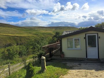
Low Bollihope Farm


Denne campingplassen mottar foreløpig ikke bestillinger på Pitchup.com.
Som eier av denne campingplassen kan du begynne å ta i mot bestillinger via Pitchup.com.
Det er gratis, raskt og enkelt!
Type campingplass
Språk som snakkes
![]() Engelsk
Engelsk
Campingplasser i nærheten som kan bestilles på Pitchup.com
Vi har dessverre ingen campingplasser med ledige enheter i nærheten.
Vil du vite mer om camping i Co. Durham?
Funksjoner
![]() Hunder ikke tillatt
Hunder ikke tillatt
Fritidsaktiviteter på stedet
Bar eller klubbhus Barneklubb Fisking Innendørs basseng Kveldsunderholdning Lekeplass Restaurant/Kafé på plassen Spillerom Sykkelutleie TV-rom Takeaway Tennis Treningssenter Utendørs basseng VannsportBekvemmeligheter på stedet
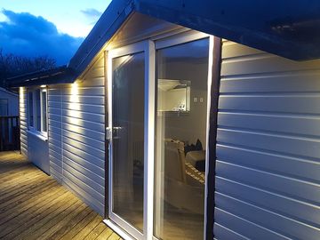
Badekar tilgjengelig Bilparkering ved plassen/enheten Bærbart toalett Dusj tilgjengelig Familietoaletter Gratis WiFi Henting fra offentlig transport Hundepark Internettilgang Ispakkekjøling Kompost-toaletter Matbutikk Myntvaskeri Offentlig telefon Oppvaskområde Pub-toaletter Toalettblokk Tørkerom WiFiGrupper velkomne
Familievennlig Grupper av samme kjønn velkomne Motorsykkelvennlig Studentgrupper velkomneRegler
Bål tillatt Griller tilgjengelig Grilling tillatt Hunder ikke tillatt Hunder tillatt Nyttekjøretøy tillattTemaer
Avsidesliggende Fredelig Naturparadis Paradis for vandringsfolk Skog Spektakulært landskapTjenester
Fornybar energi Gassflasker tilgjengelig Ladefasiliteter Ladestasjoner for el-biler Resirkulering tilgjengelig Tømming av kjemisk avfallBekvemmeligheter i nærheten
Bar i nærheten Bondens marked i nærheten Butikk i nærheten Hundelufteområde i nærheten Offentlig transport i nærhetenType
Bondegård Mini (1-10 plasser)Fritidsaktiviteter i nærheten
Hesteridning i nærheten Kano/Kajakk i nærheten Klatring i nærheten Restaurant i nærheten Sykkelutleie i nærheten Sykling i nærheten Terrengsykling i nærheten Utendørs basseng i nærhetenBeliggenhet
Low Bollihope Farm
Low Bollihope
Frosterley
Co. Durham
England
DL13 2SY
Tidssone
Europe/London +0100 (GMT+01:00)
GPS
54,71239°N
1,97728°V
Veibeskrivelse av ruten
Nærmeste transport
Legg merke til: Alle avstander på siden er beregnet i luftlinje – undersøk faktisk avstand basert på transportmetode og Få veibeskrivelse-knappen over.
Lokale attraksjoner
Vannkvaliteten ved nærliggende badevann
| Navn | Avstand | Type | 2020 | 2019 | 2018 | 2017 |
|---|---|---|---|---|---|---|
| Seaham Hall Beach | 43,6 km | Hav | N/A | Bra | Bra | Utmerket |
| Seaham Beach | 43,7 km | Hav | N/A | Bra | Utmerket | Utmerket |
| Roker - Sunderland | 45,8 km | Hav | N/A | Utmerket | Utmerket | Utmerket |
| Seaburn - Sunderland | 46,5 km | Hav | N/A | Utmerket | Utmerket | Utmerket |
| Crimdon | 46,8 km | Hav | Bra | Utmerket | Utmerket | Utmerket |
Datakilde: European Environment Agency
Må oppleves
High Force Waterfall 15 km
Barnard Castle 17,8 km
The Bowes Museum 19,3 km
Locomotion:The National Railway Museum at Shildon 23,6 km
Durham Cathedral 26,6 km
National Trust
Gibside 27,9 km
Cherryburn 28 km
Allen Banks and Staward Gorge 36,2 km
Washington Old Hall 36,2 km
Holy Jesus Hospital 37,2 km
Sykkelruter
Finn lokale ruter i National Cycle Network - over 19000 km med sykkelruter.
Annet
Stanhope - Stanhope Dene - Stanhope Burn Mine 4,3 km
Stanhope - Crookledy Crag - Stanhope 4,4 km
Circular Walk by Wolsingham 6 km
Wolsingham and Tunstall Reservoir 6,4 km
Tunstall Reservoir 7,7 km
Legg merke til: Alle avstander på siden er beregnet i luftlinje – undersøk faktisk avstand basert på transportmetode og Få veibeskrivelse-knappen over.
Vurderinger
Ingen vurderinger foreløpig.
Ofte stilte spørsmål
- Har Low Bollihope Farm et svømmebasseng? Nei Se alle funksjoner
- Er Low Bollihope Farm hundevennlig? Nei Se alle funksjoner
- Hvilke attraksjoner finnes i nærheten av Low Bollihope Farm? Along its 77-mile length, the Weardale Way roughly follows the course of the River Wear, taking in woods, farmland, moors and villages as it meanders. To make it a bit more manageable … Les mer
- Når kan jeg sjekke inn på og sjekke ut av Low Bollihope Farm?
Les merInnkvartering på stedet Ankomst: 2 p.m. – Når som helst Avvreise innen: 11:30 a.m.