Low Bollihope Farm


Deze camping neemt momenteel geen reserveringen aan via Pitchup.com.
Als je de eigenaar van deze camping bent, begin dan met boekingen aannemen via Pitchup.com.
Het is gratis, snel en makkelijk!
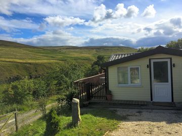
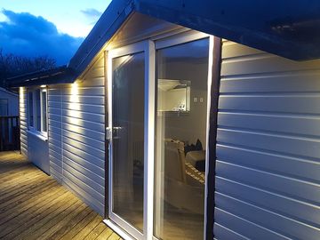
- Elegant en modern chalet net naast de Weardale Way bij Frosterley
- Op een halfuur rijden van Durham en Hamsterley Forest
- Goed uitgeruste keuken, badkamer en terrasbalkon
Parktype
Gesproken talen
![]() Engels
Engels
Nabijgelegen accommodaties die beschikbaar zijn op Pitchup.com
Helaas, wij hebben geen nabijgelegen boekbare campings.
Wil je meer weten over kamperen in Co. Durham?
Voorzieningen
![]() Honden niet toegestaan
Honden niet toegestaan
Activiteiten op de camping
Afhaaldienst Avondprogramma Bar of clubhuis Binnenzwembad Buitenzwembad Fietsverhuur Fitnesscentrum Kinderclub Restaurant/café op de camping Speeltuin Spelletjeskamer Tennis Tv-ruimte Vissen WatersportenVoorzieningen op de camping
Afwasruimte Bad aanwezig Boodschappenwinkel Composttoilet Douche aanwezig Draagbaar toilet Droogruimte Gezinsbadkamer Gratis wifi Hondenpark Internetaansluiting Openbare telefoon Parkeren bij staanplaats/accommodatie Toiletgebouw Toiletten in pub Transferservice naar openbaar vervoer Vriezer voor koelelementen Wasserette WifiGroepen welkom
Familievriendelijk Mannen/vrouwengroepen welkom Motorrijders welkom Studentengroepen welkomRegels
Barbecue voorzien Barbecues toegestaan Bedrijfswagens toegestaan Honden niet toegestaan Honden toegestaan Kampvuur toegestaanThema's
Afgelegen Bos Natuurparadijs Spectaculaire omgeving Vredig WandelparadijsFaciliteiten
Afvoerpunt chemische toiletten Gasflessen aanwezig Groene energie Oplaadpunt aanwezig Oplaadpunt(en) voor elektrische auto's RecyclingType
Boerderij Mini (1-10 staanplaatsen)Voorzieningen in de buurt
Bar in de buurt Boerenmarkt in de buurt Boodschappenwinkel in de buurt Hondenuitlaatplaats in de buurt Openbaar vervoer in de buurtActiviteiten in de buurt
Buitenzwembad in de buurt Fietsen in de buurt Fietsverhuur in de buurt Kanoën/kajakken in de buurt Klimmen in de buurt Mountainbiken in de buurt Paardrijden in de buurt Restaurant in de buurtLocatie
Low Bollihope Farm
Low Bollihope
Frosterley
Co. Durham
Engeland
DL13 2SY
Tijdzone
Europe/London +0100 (GMT+01:00)
GPS
54,71239°N
1,97728°W
Routebeschrijving
Dichtstbijzijnd vervoer
Let op: Alle afstanden op deze pagina zijn hemelsbreed berekend – controleer daarom de werkelijke afstand, afhankelijk van hoe je reist, door op de knop 'Ga naar routebeschrijving' hierboven te klikken.
Lokale bezienswaardigheden
Waterkwaliteit van nabijgelegen zwemwater
| Naam | Afstand | Type | 2020 | 2019 | 2018 | 2017 |
|---|---|---|---|---|---|---|
| Seaham Hall Beach | 43,6 km | Zee | n.v.t. | Goed | Goed | Uitstekend |
| Seaham Beach | 43,7 km | Zee | n.v.t. | Goed | Uitstekend | Uitstekend |
| Roker - Sunderland | 45,8 km | Zee | n.v.t. | Uitstekend | Uitstekend | Uitstekend |
| Seaburn - Sunderland | 46,5 km | Zee | n.v.t. | Uitstekend | Uitstekend | Uitstekend |
| Crimdon | 46,8 km | Zee | Goed | Uitstekend | Uitstekend | Uitstekend |
Bron gegevens: Europees Milieuagentschap
Populaire bezienswaardigheid
High Force Waterfall 15 km
Barnard Castle 17,8 km
The Bowes Museum 19,3 km
Locomotion:The National Railway Museum at Shildon 23,6 km
Durham Cathedral 26,6 km
Nationaal Beheer
Gibside 27,9 km
Cherryburn 28 km
Allen Banks and Staward Gorge 36,2 km
Washington Old Hall 36,2 km
Holy Jesus Hospital 37,2 km
Fietsroutes
Vind lokale routes op het National Cycle Network - bijna 20.000 kilometer aan fietsroutes.
Anders
Stanhope - Stanhope Dene - Stanhope Burn Mine 4,3 km
Stanhope - Crookledy Crag - Stanhope 4,4 km
Circular Walk by Wolsingham 6 km
Wolsingham and Tunstall Reservoir 6,4 km
Tunstall Reservoir 7,7 km
Let op: Alle afstanden op deze pagina zijn hemelsbreed berekend – controleer daarom de werkelijke afstand, afhankelijk van hoe je reist, door op de knop 'Ga naar routebeschrijving' hierboven te klikken.
Beoordelingen
Nog geen beoordelingen.
Veelgestelde vragen
- Heeft Low Bollihope Farm een zwembad? Nee Bekijk alle faciliteiten
- Is Low Bollihope Farm hondvriendelijk? Nee Bekijk alle faciliteiten
- Welke attracties liggen in de buurt van Low Bollihope Farm? Along its 77-mile length, the Weardale Way roughly follows the course of the River Wear, taking in woods, farmland, moors and villages as it meanders. To make it a bit more manageable … Lees meer
- Wanneer kan ik in- en uitchecken bij Low Bollihope Farm?
Lees meerAccommodatie op het park Aankomst: 14:00 – op elk moment Vertrek voor: 11:30