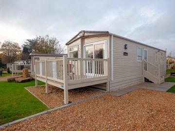
Shireburne Park


Dieser Platz nimmt auf Pitchup.com gerade keine Buchungen entgegen.
Wenn Sie der Besitzer dieses Campingplatzes sind, können Sie mithilfe von Pitchup.com zusätzliche Buchungen erhalten.
Es ist kostenlos, schnell und einfach!
- Ruhiger Anlage in Ribble Valley, mit Blick auf den Pendle Hill
- 50 Min zum Forest of Bowland, nach Pendle und zu den Yorkshire Dales
- Wochenendbar; 5 Autominuten zu den Märkten und zum Clitheroe Schloss
Art des Platzes
Gesprochene Sprachen
![]() Englisch
Englisch
Nahe gelegene Plätze, die auf Pitchup.com buchbar sind
Leider gibt es in der Umgebung keine buchbaren Plätze.
Lancashire: Mehr übers Campen erfahren?
Ausstattung
![]() Hunde gestattet
Hunde gestattet
Freizeiteinrichtungen am Platz
Abendunterhaltung Angeln Bar oder Clubhaus Eigenes Restaurant/Cafe Fahrradverleih Fernsehraum Fitnesscenter Freischwimmbecken Gerichte zum Mitnehmen Hallenbad Kinderclub Spielplatz Spielzimmer Tennis WassersportPlatzausstattung
Abholung vom Bahnhof/Busbahnhof Auto-Parkmöglichkeit am Stellplatz/bei der Unterkunft Badewanne vorhanden Dusche vorhanden Eisbeutel-Kühlservice Familienwaschräume Geschirrspülraum Gratis WLAN Internet-Anschluss Komposttoilette Lebensmittelgeschäft Mobiltoilette Park für Hunde Sanitärgebäude Toiletten im Pub Trockenraum WLAN Waschküche Öffentliches TelefonGruppenregelungen
Familienfreundlich Frauen-/Männergruppen willkommen Motorradfreundlich Studentengruppen willkommenRegeln
Grill wird zur Verfügung gestellt Grillen gestattet Hunde ganzjährig gestattet Hunde gestattet Lagerfeuer gestattet Nutzfahrzeuge gestattetThemen
Eindrucksvolle Landschaft Friedlich Kulinarische Angebote Naturparadies Wald WanderparadiesAusstattung
Chemie-WC Entsorgung Erneuerbare Energie Gasflaschen-Service Ladestation(en) für Elektroautos Ladestationen Recycling vorhandenEinrichtungen in der Umgebung
Bar in der Nähe Gassi gehen in der Nähe Lebensmittelgeschäft in der Nähe Öffentliche Transportmittel in der NäheTyp
Mini (1-10 Stellplätze)Freizeitaktivitäten in der Umgebung
Angeln in der Nähe Fahrradverleih in der Nähe Golf in der Nähe Hallenbad in der Nähe Kanus/Kajaks in der Nähe Mountainbike-Routen in der Nähe Radfahren in der Nähe Reitmöglichkeit in der Nähe Restaurant in der Nähe Tennis in der NäheLage
Shireburne Park
Edisford Road
Waddington
Clitheroe
Lancashire
England
BB7 3LB
Zeitzone
Europe/London +0100 (GMT+01:00)
GPS
53,87442°N
-2,41572°W
Öffentliche Verkehrsmittel in der Nähe
Bitte beachten: Alle auf dieser Seite angegebenen Entfernungen sind auf "Luftlinien-Basis" berechnet - bitte die exakte Entfernung unter Berücksichtigung des Transportmittels mithilfe des Feldes Wegbeschreibung oben überprüfen.
Sehenswürdigkeiten in der Nähe
Wasserqualität umliegender Gewässer
| Name | Entfernung | Art | 2020 | 2019 | 2018 | 2017 |
|---|---|---|---|---|---|---|
| Morecambe North | 36,8 km | Mündung | Gut | N/A | Gut | Gut |
| Morecambe South | 37,3 km | Meer | N/A | N/A | Gut | Gut |
| Fleetwood | 40 km | Meer | N/A | Gut | Gut | Gut |
| Cleveleys | 41,5 km | Meer | N/A | Gut | Gut | Gut |
| Bispham | 42 km | Meer | N/A | Gut | Gut | Gut |
Datenquelle: Europäische Umweltagentur
Must-see
Gawthorpe Hall 11,2 km
Oswaldtwistle Mills 14,2 km
Beacon Fell Country Park 15,9 km
Forest of Bowland 23,6 km
Bronte Parsonage Museum 30,4 km
National Trust
Gawthorpe Hall 11,2 km
Hardcastle Crags 28,4 km
Malham Tarn Estate 29,8 km
East Riddlesden Hall 35 km
Rufford Old Hall 37,1 km
Radwege
Umliegende Radwege des Nationalen Radnetzes finden - über 19.000 Kilometer an Radwegen
Andere
Edisford - Brungerly - Chatburn - West Bradford - Edisford 0,6 km
Waddington and the Moorcock by Wadddington Brook 1,5 km
CLITHEROE CASTLE 1,6 km
Journey through the Centre of the Kingdom, Section 1: Clitheroe - Chatburn 1,6 km
Waddington, West Bradford and the Moorcock 1,8 km
Veranstaltungen in der Nähe
- Lytham Festival (Mittwoch, 2. Juli 2025 – Mittwoch, 2. Juli 2025)
Lytham St Annes, England 39,1 km
Bitte beachten: Alle auf dieser Seite angegebenen Entfernungen sind auf "Luftlinien-Basis" berechnet - bitte die exakte Entfernung unter Berücksichtigung des Transportmittels mithilfe des Feldes Wegbeschreibung oben überprüfen.
Angebote
Bedingungen gelten - Details im Bereich Stellplatztypen
Bewertungen
Noch keine Bewertungen
Häufig gestellte Fragen
- Gibt es im Shireburne Park ein Schwimmbecken? Nein Alle Eigenschaften ansehen
- Ist Shireburne Park hundefreundlich? Ja Alle Eigenschaften ansehen
- Welche Attraktionen finde ich in der Nähe von Shireburne Park? For walks and tales of witches, Pendle Hill is half an hour's drive away and paths up to the top start from Barley. To learn about those infamous 17th-century witch trials, head … Mehr erfahren
- Wann kann ich im Shireburne Park ein- und auschecken?
Mehr erfahrenUnterkunft vor Ort Ankunft: 15:00 – 22:00 Abreise bis: 10:30